Honeymoon over.
The first half of September has been dry. Only one day has produced measurable rainfall in Central Park, totaling less than a quarter inch so far for the month. But this sunny and dry streak will come to an end, thanks to a low-pressure system off the coast of South Carolina.
Thankfully, the week does not start on a soggy note. Both Monday and Tuesday stay rain-free with temperatures in the upper 70s. Outdoor plans will be unencumbered, so get outside and enjoy; the umbrella can stay at home.

By Wednesday, rain returns to the tri-state. Showers, along with some isolated downpours, are likely during the day. The timing of the heavier showers could coincide with the morning and evening drives, so anticipate longer-than-normal commutes.

Spotty shower chances linger into Thursday and even Friday. Pack a small umbrella with you through the end of the week to be safe.

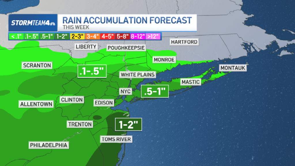
The exact track of this low-pressure system remains a little uncertain, and that will dictate exactly how much rain we get. For now, the greatest rain totals stay confined to our south while the rest of New Jersey, Long Island, and the city will get less than an inch.
The Hudson Valley can expect the lowest rain totals, with less than a tenth of an inch for most.

Our lack of rainfall this month has left parts of South and Central Jersey in the “abnormally dry” category on the drought monitor. So even though an end to our sunny streak doesn’t sound like something to look forward to, it will be good for our area to get some more rain this month.

Along with the rain, the coastal low will bring a gusty easterly wind along the shorelines. This will contribute to a high risk of dangerous rip currents beginning Tuesday.
The onshore flow also coincides with Tuesday’s full moon, increasing the chance for some minor coastal flooding.

Skies dry out significantly heading into the weekend, in time for the official start of Autumn on Sunday. And temperatures are going to feel like it.


