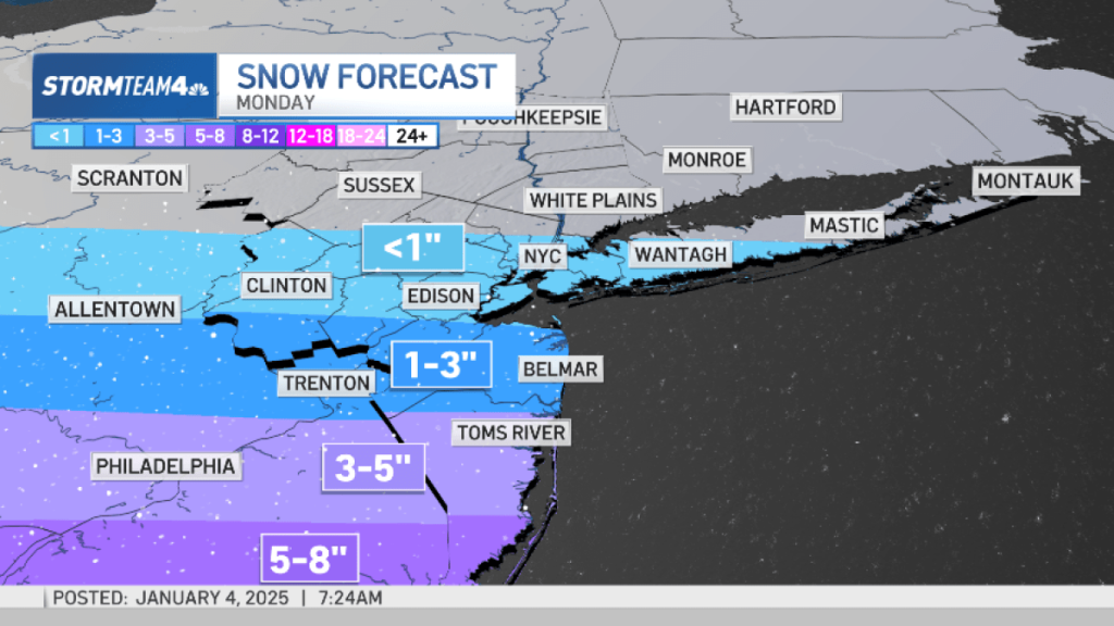
Don’t let this weekend dry weather fool you. Snow is on the way for parts of the tri-state on Monday.
It will be breezy, cool and dry on Saturday. Winds are back up today with wind chills dipping into the teens and 20s during the day, single digits and low teens tonight. It’s essentially the same tomorrow. If any flakes fly, it’ll be off the ends of Lake Effect bands.
Looking ahead to Monday, a Winter Storm Watch is planned for Ocean County, New Jersey from late Sunday through late Monday.
There are no major changes to our forecast for Monday. We are still expecting most of the snow to be well south of New York City. Central and south Jersey will see snow totals worthy of breaking out the shovel.
South Jersey will see the most significant snow with a widespread 6+ inches likeliest.

Starting early Monday, for most, the timing of the snow will start late AM commute, and will continue through at least the early PM commute.


The models are still favoring a more southward storm, so it’s entirely possible still for the city, Long Island, northern NJ and the Hudson Valley to see little-to-nothing from this system.
Dangerous, treacherous and near-impossible travel will be starting later today for parts of the central plains due to ice and snow. This system moves into the Ohio Valley and Mid-Atlantic tomorrow, along with severe weather in the South.

By Monday, the heavier snow will be from DC/Baltimore/Philadelphia so NE airports will be effected.
Beyond Monday: winds crank up AGAIN in the 35+ mph range in the wake of Monday’s system as we get entrenched in the chill through the end of the week.


