Winter storm blasts NY, NJ
More than a foot of snow fell in parts of Upstate New York and northeastern Pennsylvania as a potent early-season snowstorm blasted the Northeast with snow and beneficial rain.
NEW YORK – As Thanksgiving travelers hit the road, a potent early-season snowstorm over the Northeast caused travel delays and disruptions.
JUMP TO: NYC LIVE CAM l STORM TIMELINE l WHAT’S NEXT l WINTER PREDICTION
More than a foot of snow fell in parts of Upstate New York and northeastern Pennsylvania, according to the FOX Forecast Center. High Point, New Jersey reported 20 inches of snow, while 19 inches fell in Cortez, Pennsylvania and 17.1 inches were on the ground in Franklin, New York.
24/7 NYC Live Cam | Times Square, skyline, streets, more
Traffic along Interstate 84 near Scranton, Pennsylvania ground to a halt Friday morning as heavy snow covered the roads and dimmed visibility.
Winter weather put a halt to air travel at Greater Binghamton Airport in Johnson City, New York. Delays and cancellations were also reported at other major airport hubs in New York, Boston and Washington.
Weather observation sites in both Wilkes Barre and Binghamton reported some of their heaviest snowfall tallies on record in November, which caused extensive power outages.
More than 125,000 power outages were reported in New York and Pennsylvania due to falling trees.
Local utility companies pledged to have the majority of the outages restored by the end of the weekend.
Did it snow last night?
Parts of Sussex County, New Jersey saw over 10 inches of snow.
NY, NJ see first snow of the season
A winter storm system brought rain, strong winds and even snow to parts of the Tri-State area. FOX 5 NY’s Briella Tomassetti has the latest.
In addition, snow fell as far south as Westchester County, with heavy, wet snow covering the roads overnight and making driving difficult.
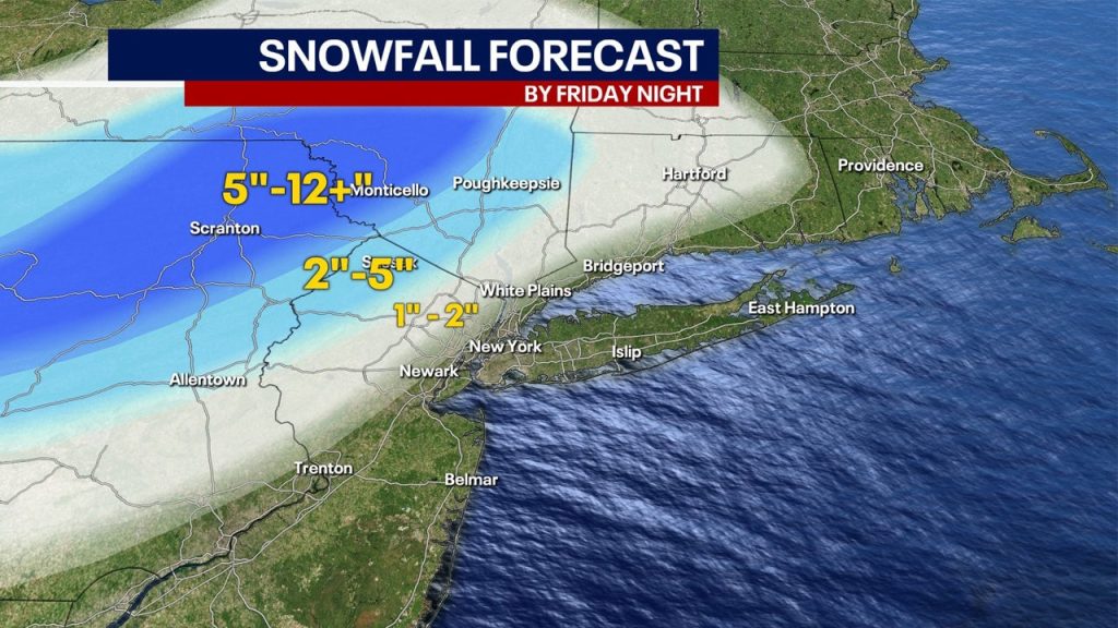
Low pressure will spin over the region into Saturday, resulting in more rain and potential snow. Over a foot of snow fell in parts of Upstate New York and northeastern Pennsylvania, according to the FOX Forecast Center.
This graphic shows the forecast snow totals in the mid-Atlantic and Northeast. (FOX Weather)
“Keeps us pretty wet all the way through tomorrow morning, then it kinda of breaks up as time goes on, and we will see a gradual clearing through Saturday,” FOX 5 NY’s Woods said.
Delays and cancelations were reported at airport hubs in New York. Winter Storm Warnings remain in effect for areas including New York and Pennsylvania. Winter Weather Advisories also remain in portions of New York and New Jersey.

Snow-covered roads in Westchester County.
In the lower elevations of the mid-Atlantic, some snow bands could pivot as far southeast as the Interstate 95 corridor. So, while accumulations in areas such as New York City are expected to be minimal, if any, the city could see its first “falling” snow of the season by Friday afternoon.
Across the Tri-State area, rain totals should remain in the 1-2 inch range, although locally higher amounts of 2-3 inches or more are possible in some areas.

This graphic shows forecast rain totals in the Northeast. (FOX Weather)
What’s next?
Behind the storm system, the coldest air of the season will pour south out of Canada in the days after Thanksgiving and into the start of December. Much of the country will experience below-average temperatures as travelers head home, the FOX Forecast Center said. In addition, is another storm on the way?
“Unsettled wintry weather is possible with this system, and a slight risk (20 to 40 percent chance) of heavy snow is indicated across parts of the Great Lakes and Interior Northeast, the day after Thanksgiving into the Holiday weekend,” the NOAA NWS Climate Prediction Center said in a post on Facebook.
Flight status
Check the status of each airport below:
LaGuardia Airport
- For more information from the FAA, click HERE.
Newark Airport
- For more information from the FAA, click HERE.
JFK Airport
- For more information from the FAA, click HERE.
FOX 5 NY’s Nick Gregory predicts the city could receive around 20 inches of snow this winter, compared to the typical seasonal average of 28 inches.
“We’ll likely have above average temperatures this winter along with more snow than last year, with somewhere near 18-23″, but that is below the average snowfall for a winter in NYC,” Gregory said.
Meanwhile, the lower Hudson Valley could see slightly more snowfall, with totals ranging between 20 and 25 inches, with more snowfall further north. Much of the winter may bring a mix of rain and snow along the coast, with heavier snow falling further north.
When will it snow in NYC?
Historically, the first measurable snow (accumulation of one inch or more) tends to fall in the NYC area around Dec. 13. The earliest measurable snowfall was on October 29, 2011, when 2.9 inches fell days before Halloween.
When is the first day of winter?
Winter officially begins in the Northern Hemisphere on Dec. 21 with the winter solstice – the day with the least amount of possible daylight and the longest night.
NYC weather radar
Click HERE for more.

