


FLORIDA – Hurricane Helene intensified into a catastrophic Category 4 hurricane with winds of 130 mph on its final approach to Florida’s Big Bend region, bringing a potentially “unsurvivable” 20-foot storm surge, catastrophic hurricane-force winds and flooding rain.
LATEST ON HURRICANE HELENE: LOCATION l PROJECTED PATH l IMPACTS
***Click each headline to jump to the designated topic.
The National Hurricane Center (NHC) warned that Hurricane Helene will continue to intensify before it makes landfall.
Storm surge became a problem for Southwest Florida ahead of Helene’s landfall. St. Petersburg and Naples reported an increase in water levels of over 2 feet.
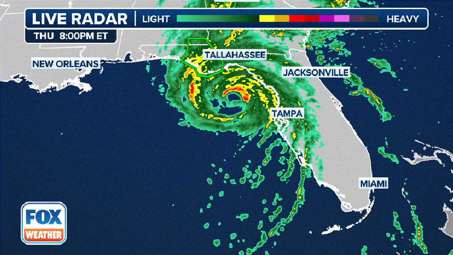
Current stats and satellite for Hurricane Helene. (FOX Weather)
The National Hurricane Center (NHC) said there is a significant risk of a life-threatening storm surge along the entire west coast of the Florida Peninsula, as well as Florida’s Big Bend region because of Hurricane Helene’s massive size.
Here’s everything you need to know about Hurricane Helene, including its location, projected path and impacts.
As of the latest advisory from the NHC, Hurricane Helene was located about 120 miles southwest of Tampa and was moving to the north-northeast at 23 mph.

Current location of Hurricane Helene. (FOX Weather)
Maximum sustained winds have increased to 130 mph, making it a Category 4 hurricane.
Hurricane Helene projected path: When will the storm make landfall?
The NHC warns Helene will continue to intensify and could become a Category 3 hurricane with winds of 115 mph or higher when it makes landfall along Florida’s Big Bend region Thursday night or early Friday morning.
On its current track, the National Hurricane Center (NHC) said Hurricane Helene is forecast to make landfall along the Florida Big Bend on Thursday evening as a Category 4 hurricane with winds of at least 130 mph.
After landfall, Helene is forecast to slow down and turn northwest, moving over the Southeast through Friday and Saturday.
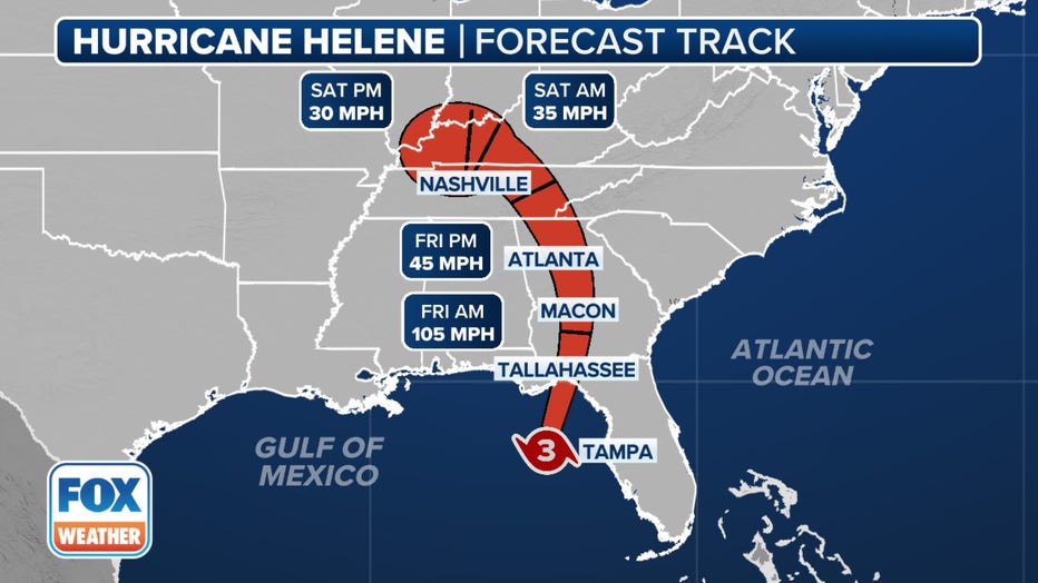
Forecast cone for Hurricane Helene.(FOX Weather)
Tropical-storm-force winds will be felt in South Carolina as soon as Thursday and across the Southeast through Saturday, with peak gusts up to hurricane strength in parts of Georgia and South Carolina.
Helene is expected to track northwest into Kentucky and Tennessee, bringing gusty winds of up to 70 mph.
Hurricane Helene trajectory: Spaghetti models
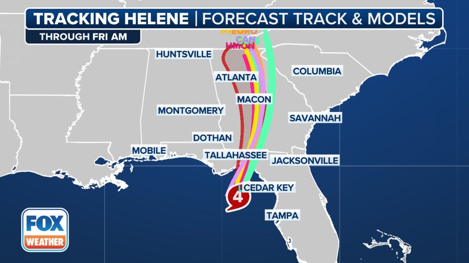
Here are the spaghetti models for Hurricane Helene.(FOX Weather)
The highest inundation, with as much as 20 feet of storm surge flooding, is expected from Carrabelle to the Suwannee River in Florida, with other locations like Apalachicola and Chassahowitzka forecast to see 10-15 feet of storm surge.
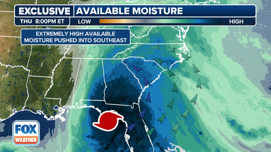
Available moisture in the Appalachians. (FOX Weather)
The large storm will bring widespread heavy rain, damaging winds and possible tornadoes to cities in the Southeast, including Atlanta and Asheville, North Carolina.

A look at the exclusive FOX Model showing wind gust potential in the Gulf Coast on Thursday.(FOX Weather)
The risk of tornadoes will increase Thursday, expanding across Florida and into parts of Georgia and South Carolina.
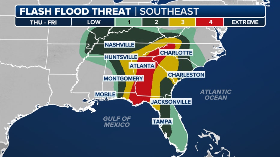
Flash flood outlook for Thursday. (FOX Weather)
The NHC is warning of total rain accumulations of 5-10 inches with isolated totals near 15 inches. Cities such as Atlanta and Augusta in Georgia and Knoxville and Chattanooga in Tennessee are among those at the greatest flash flooding risk over the next five days.

Forecast rain totals.(FOX Weather)
What’s next?
An area being watched is a tropical disturbance dubbed Invest 98L in the eastern tropical Atlantic.
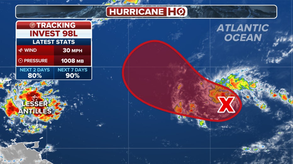
A look at the latest odds of development for Invest 98L in the Atlantic. (FOX Weather)
Showers and thunderstorms have become more organized Thursday morning along a tropical disturbance located several hundred miles west of the Cabo Verde Islands, according to the NHC.
A tropical depression or tropical storm is likely to form as soon as Thursday while it moves westward to west-northwestward across the eastern and central tropical Atlantic. If Invest 98L does develop into a tropical storm, it will be named Joyce.
FOX Weather helped contribute to this report.


